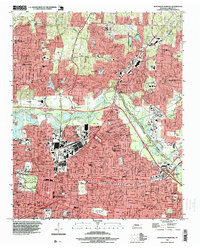
1997 Map of Northeast Memphis
USGS Topo · Published 1999About this map
The Wolf River meanders across this late 20th-century landscape, where industrial infrastructure meets historic residential neighborhoods. The extensive rail network of the Illinois Central RR and L & N RR serves the Hollywood Yards and surrounding commercial zones, while significant landmarks like the Memphis National Cemetery and Overton Park provide large green spaces amid the urban grid. This 1990s planimetry reveals the established institutions of the area, including Christian Brothers College, the Memphis Museum, and numerous educational sites like Trezevant High Sch. The map records a transition from the dense streetscapes of Memphis to the growing suburban footprint of Bartlett, punctuated by local landmarks like Hawkins Mill and several smaller water bodies such as Lake Windermere and Sky Lake.
Find a feature on this map
86 named features on this map. Tap any name to fly to it.
Don’t see what you’re looking for? This feature index may not catch every label — zoom into the map to look around manually.
Map Details
Editions of this 1997 Northeast Memphis Map
This is the sole edition of this map. No revisions or reprints were ever made.
Other maps of this area

1916 · Memphis
USGS Topo · 1:62,500

1925 · Memphis
USGS Topo · 1:48,000

1927 · Memphis
USGS Topo · 1:62,500

1931 · Jericho
USGS Topo · 1:62,500

1939 · Jericho
USGS Topo · 1:62,500

1939 · Memphis
USGS Topo · 1:62,500

1942 · Millington
USGS Topo · 1:62,500

1952 · Jericho
USGS Topo · 1:62,500

1953 · Memphis
USGS Topo · 1:250,000

1955 · Memphis
USGS Topo · 1:62,500