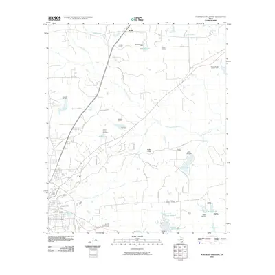
2010 Map of Northeast Palestine
USGS Topo · Published 2010About this map
Palestine occupies the southwestern corner of this survey, where the urban grid gives way to a landscape defined by an extensive network of small lakes and family-named cemeteries. In the north, the settlement of Mound Prairie sits near the headwaters of Mound Prairie Creek, while the rest of the quadrangle is etched with creeks like Wells Creek and Hurricane Creek that feed a series of reservoirs. These water bodies, including Lost Prairie Lake, Haverlah Lake, and Grover C Walker Lake, underscore the regional reliance on managed water resources for agriculture and recreation.
Find a feature on this map
78 named features on this map. Tap any name to fly to it.
Don’t see what you’re looking for? This feature index may not catch every label — zoom into the map to look around manually.
Map Details
Editions of this 2010 Northeast Palestine Map
This is the sole edition of this map. No revisions or reprints were ever made.
Other maps of this area

1949 · Palestine
USGS Topo · 1:62,500

1950 · Palestine
USGS Topo · 1:62,500

1951 · Elkhart
USGS Topo · 1:62,500

1951 · Jacksonville
USGS Topo · 1:62,500

1952 · Slocum
USGS Topo · 1:62,500

1953 · Palestine
USGS Topo · 1:250,000

1957 · Palestine
USGS Topo · 1:250,000

1981 · Palestine
USGS Topo · 1:100,000
1982 · Northwest Palestine
USGS Topo · 1:24,000
1982 · Wilkerson Mountain
USGS Topo · 1:24,000