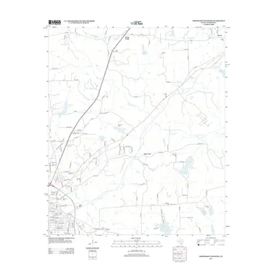
2013 Map of Northeast Palestine
USGS Topo · Published 2013About this map
Mound Prairie and Wells Creek anchor this East Texas landscape in Anderson County, where a dense network of country roads connects family burial grounds and small water bodies. The terrain is defined by the drainage of Mound Prairie Creek and Hurricane Creek, which feed numerous small reservoirs such as Jackson Lake, Haverlah Lake, and Hudson Lake. To the south, the city of Palestine begins to influence the map with developed areas like Perlang Est and local landmarks including Spring Park Lake. Genealogists will find a wealth of data points across the rural countryside, from Pine Ridge Cemetery in the north to the cluster of Saint Josephs Cemetery, Memorial Cemetery, and E Hill Cemetery on the edge of the Palestine townsite. The infrastructure of the era is represented by state routes like FM-321, which winds past Lumpkin Cemetery toward the community of Neches.
Find a feature on this map
117 named features on this map. Tap any name to fly to it.
Don’t see what you’re looking for? This feature index may not catch every label — zoom into the map to look around manually.
Map Details
Editions of this 2013 Northeast Palestine Map
This is the sole edition of this map. No revisions or reprints were ever made.
Other maps of this area

1949 · Palestine
USGS Topo · 1:62,500

1950 · Palestine
USGS Topo · 1:62,500

1951 · Elkhart
USGS Topo · 1:62,500

1951 · Jacksonville
USGS Topo · 1:62,500

1952 · Slocum
USGS Topo · 1:62,500

1953 · Palestine
USGS Topo · 1:250,000

1957 · Palestine
USGS Topo · 1:250,000

1981 · Palestine
USGS Topo · 1:100,000
1982 · Northwest Palestine
USGS Topo · 1:24,000
1982 · Wilkerson Mountain
USGS Topo · 1:24,000