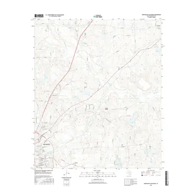
2016 Map of Northeast Palestine
USGS Topo · Published 2016About this map
Palestine anchor the southwestern corner of this landscape, where the urban grid gives way to a dense network of water bodies and rural cemeteries in Anderson County. The area is defined by its diverse hydrology, including the winding course of Wells Creek and larger impoundments like Lost Prairie Lake and Haverlah Lake. This topography suggests a land utilized for recreation and small-scale agriculture, as numerous family and community burial sites are scattered throughout the countryside. Genealogists can trace historical burial grounds such as Pine Ridge Cem and Lumpkin Cem in the north, while the southern reaches feature more contemporary memorial sites like Roselawn Park Cem. The small settlement of Neches stands in the northeast, connected to the county seat by a system of country roads and state highways that bridge the many small tributaries of Mound Prairie Cr and Hurricane Cr.
Find a feature on this map
108 named features on this map. Tap any name to fly to it.
Don’t see what you’re looking for? This feature index may not catch every label — zoom into the map to look around manually.
Map Details
Editions of this 2016 Northeast Palestine Map
This is the sole edition of this map. No revisions or reprints were ever made.
Other maps of this area

1949 · Palestine
USGS Topo · 1:62,500

1950 · Palestine
USGS Topo · 1:62,500

1951 · Elkhart
USGS Topo · 1:62,500

1951 · Jacksonville
USGS Topo · 1:62,500

1952 · Slocum
USGS Topo · 1:62,500

1953 · Palestine
USGS Topo · 1:250,000

1957 · Palestine
USGS Topo · 1:250,000

1981 · Palestine
USGS Topo · 1:100,000
1982 · Northwest Palestine
USGS Topo · 1:24,000
1982 · Wilkerson Mountain
USGS Topo · 1:24,000