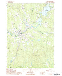
1987 Map of Northfield
USGS Topo · Published 1987About this map
The Winnipesaukee River carves through the center of this New Hampshire landscape, defining the industrial and social development of Tilton and Northfield. By the late 1980s, the area shows a distinct clustering of commerce and residence along the river corridor, while the surrounding hills remain largely forested or punctuated by family-named landmarks like Calef Hill and Bean Hill. The transition between Belknap and Merrimack counties is clearly marked as it follows the river's path, highlighting how the waterway served as both a natural boundary and a shared resource for the twin towns.
Find a feature on this map
39 named features on this map. Tap any name to fly to it.
Don’t see what you’re looking for? This feature index may not catch every label — zoom into the map to look around manually.
Map Details
Editions of this 1987 Northfield Map
This is the sole edition of this map. No revisions or reprints were ever made.
Other maps of this area

1909 · Winnepesaukee
USGS Topo · 1:62,500

1919 · Gilmanton
USGS Topo · 1:62,500

1925 · Holderness
USGS Topo · 1:62,500

1927 · Penacook
USGS Topo · 1:62,500

1927 · Gilmanton
USGS Topo · 1:62,500

1927 · Holderness
USGS Topo · 1:62,500

1949 · Portland
USGS Topo · 1:250,000

1956 · Winnipesaukee
USGS Topo · 1:62,500

1956 · Penacook
USGS Topo · 1:62,500

1956 · Holderness
USGS Topo · 1:62,500