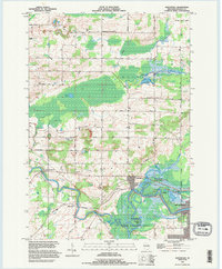
1993 Map of Northport
USGS Topo · Published 1995About this map
The Wolf River and its confluence with the Little Wolf River define the landscape of this Waupaca County region, which transitions from wetlands to agricultural hillsides. The small community of Northport serves as a central hub, flanked by the river-bend settlement of Ostrander and the town of Royalton to the west. Low-lying marshlands are preserved within the Wolf River State Fishery Area and the State Wildlife Area, where the river winds through distinctive curves like Shirtail Bend.
Find a feature on this map
50 named features on this map. Tap any name to fly to it.
Don’t see what you’re looking for? This feature index may not catch every label — zoom into the map to look around manually.
Map Details
Editions of this 1993 Northport Map
This is the sole edition of this map. No revisions or reprints were ever made.
Other maps of this area

1955 · Embarrass
USGS Topo · 1:48,000

1955 · Clintonville
USGS Topo · 1:48,000

1955 · Green Bay
USGS Topo · 1:250,000

1956 · New London
USGS Topo · 1:48,000

1956 · Weyauwega
USGS Topo · 1:48,000

1969 · New London
USGS Topo · 1:24,000

1969 · Readfield
USGS Topo · 1:24,000
1969 · Hortonville
USGS Topo · 1:24,000

1969 · Northport
USGS Topo · 1:24,000

1969 · Bear Creek
USGS Topo · 1:24,000