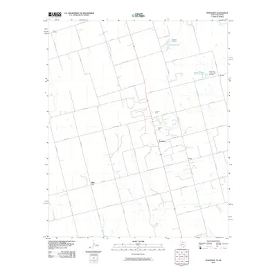
2010 Map of Northside
USGS Topo · Published 2010About this map
White City and the surrounding plains of Wilbarger County define this landscape near the Oklahoma border. The area is characterized by a grid of agricultural roads and the industrial presence of the Fargo Oil Field, which sits near the crossroads settlement of Northside. The map captures a transition from traditional farming to energy extraction, with Amerada Camp providing evidence of the local petroleum industry's footprint.
Find a feature on this map
38 named features on this map. Tap any name to fly to it.
Don’t see what you’re looking for? This feature index may not catch every label — zoom into the map to look around manually.
Map Details
Editions of this 2010 Northside Map
This is the sole edition of this map. No revisions or reprints were ever made.
Other maps of this area

1955 · Lawton
USGS Topo · 1:250,000

1958 · Davidson
USGS Topo · 1:62,500

1958 · Frederick
USGS Topo · 1:62,500

1958 · Vernon
USGS Topo · 1:62,500

1958 · Elmer
USGS Topo · 1:62,500

1975 · Elmore City NE
USGS Topo · 1:24,000

1975 · Frederick SW
USGS Topo · 1:24,000

1975 · Frederick NW
USGS Topo · 1:24,000

1983 · Tolbert
USGS Topo · 1:24,000
1983 · Vernon
USGS Topo · 1:24,000