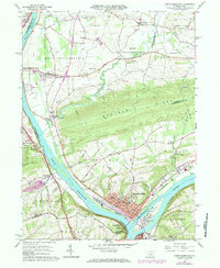
1965 Map of Northumberland
USGS Topo · Published 1984About this map
Northumberland sits at the dramatic confluence where the West Branch Susquehanna River joins the main stem, creating a landscape defined by water and transit. This survey illustrates a complex transportation corridor where the Reading and Penn Central railroads parallel the riverbanks, serving industrial sites like the Quarry near Winfield and various gravel pits. The presence of the Sodom Sch (Historic) and the Vincent Mem Chapel highlights the deep-rooted community history of West Chillisquaque. Across from the borough, Packers Island and the Shikellamy State Park overlook the river junction, while further inland, the terrain rises sharply toward Montour Ridge. The map also documents the mid-century suburban expansion of Kapp Heights and the infrastructure of the Sunbury Airport, situated just south of the historic borough center.
Find a feature on this map
73 named features on this map. Tap any name to fly to it.
Don’t see what you’re looking for? This feature index may not catch every label — zoom into the map to look around manually.
Map Details
Editions of this 1965 Northumberland Map
4 editions found

Other maps of this area

1892 · Shamokin
USGS Topo · 1:62,500

1893 · Sunbury
USGS Topo · 1:62,500

1893 · Shamokin
USGS Topo · 1:62,500

1924 · Milton
USGS Topo · 1:62,500

1935 · Hughesville
USGS Topo · 1:62,500

1943 · Shamokin
USGS Topo · 1:62,500

1943 · Sunbury
USGS Topo · 1:62,500

1950 · Harrisburg
USGS Topo · 1:250,000

1952 · Shamokin
USGS Topo · 1:62,500

1953 · Hughesville
USGS Topo · 1:62,500
Featured Places
- Sunbury, PA
- Northumberland, PA
- Monroe Township, PA
- Upper Augusta Township, PA
- Lithia Springs, Point Township