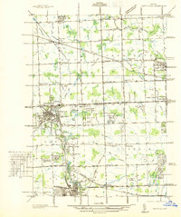
1936 Map of Northville
USGS Topo · Published 1936About this map
Northville and its surrounding townships appear here in the mid-1930s, showing a transition from agricultural roots to a landscape of specialized institutions and recreational clubs. The Middle Rouge River and its various drains, such as Bathrick Ditch and Seeley Ditch, define the drainage of this area, supporting several water bodies like Waterford Pond and Wilcox Lake. Regional connectivity is anchored by the Pere Marquette railroad and a grid of mile roads, including the prominent Grand River Ave.
Find a feature on this map
82 named features on this map. Tap any name to fly to it.
Don’t see what you’re looking for? This feature index may not catch every label — zoom into the map to look around manually.
Map Details
Editions of this 1936 Northville Map
This is the sole edition of this map. No revisions or reprints were ever made.
Other maps of this area

1902 · South Lyon
USGS Topo · 1:62,500

1904 · Ann Arbor
USGS Topo · 1:125,000

1905 · Wayne
USGS Topo · 1:62,500

1906 · South Lyon
USGS Topo · 1:62,500

1907 · Pontiac
USGS Topo · 1:62,500

1908 · Ann Arbor
USGS Topo · 1:125,000

1909 · Milford
USGS Topo · 1:62,500

1912 · Wayne
USGS Topo · 1:62,500

1936 · Inkster
USGS Topo · 1:31,680

1936 · Wayne
USGS Topo · 1:31,680