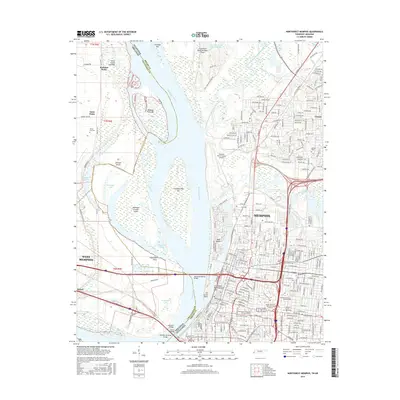
2016 Map of Northwest Memphis
USGS Topo · Published 2016About this map
The Mississippi River carves a complex path between Tennessee and Arkansas in this 2016 survey, defining the industrial and urban character of Memphis and West Memphis. The landscape is dominated by the river's dynamic hydrology, evidenced by features like Mud Island, Robinson Crusoe Island, and the Loosahatchie Bar. The map illustrates the critical infrastructure connecting the two states, including the Hernando-Desoto Bridge and the historic Harahan Bridge. On the Tennessee side, the urban grid of Memphis is densely detailed, featuring institutions such as the Southwest Tennessee Community Coll and the Southern Coll of Optometry. North of the city center, the community of Frayser sits near the Loosahatchie River Drainage Canal, while the Arkansas side remains more alluvial and less developed, showing the small settlement of Briark and the rural roads around Saint Claire. This modern topographical record highlights the ongoing relationship between the river's shifting bars and the permanent steel of the trans-Mississippi railroad bridges.
Find a feature on this map
148 named features on this map. Tap any name to fly to it.
Don’t see what you’re looking for? This feature index may not catch every label — zoom into the map to look around manually.
Map Details
Editions of this 2016 Northwest Memphis Map
This is the sole edition of this map. No revisions or reprints were ever made.
Other maps of this area

1916 · Memphis
USGS Topo · 1:62,500

1925 · Memphis
USGS Topo · 1:48,000

1927 · Memphis
USGS Topo · 1:62,500

1931 · Jericho
USGS Topo · 1:62,500

1939 · Jericho
USGS Topo · 1:62,500

1939 · Memphis
USGS Topo · 1:62,500

1942 · Millington
USGS Topo · 1:62,500

1952 · Jericho
USGS Topo · 1:62,500

1953 · Memphis
USGS Topo · 1:250,000

1955 · Memphis
USGS Topo · 1:62,500