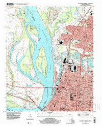
1997 Map of Northwest Memphis
USGS Topo · Published 1999About this map
The Mississippi River and Wolf River dominate this late 1990s landscape, illustrating the complex relationship between the water and the urban growth of Memphis. The map reveals a dense network of river-focused features including the Hernando-Desoto Br and Harahan Br, which connect the Tennessee city to West Memphis, Arkansas. On the Tennessee side, the bluffs and lowlands are shaped by the Loosahatchie River and Mud Island Lagoon, while the interior shows the maturing residential and industrial districts of Frayser and Georgian Hills. Notable for local history, the sheet documents numerous community landmarks such as Owen College, St Peters Orphanage, and Temple Israel. Further north, the river's dynamic nature is evidenced by St Claire Crevasse and various bars and islands like Robinson Crusoe Island, reflecting the ongoing management of the alluvial plain via the St Francis Levee.
Find a feature on this map
96 named features on this map. Tap any name to fly to it.
Don’t see what you’re looking for? This feature index may not catch every label — zoom into the map to look around manually.
Map Details
Editions of this 1997 Northwest Memphis Map
This is the sole edition of this map. No revisions or reprints were ever made.
Other maps of this area

1916 · Memphis
USGS Topo · 1:62,500

1925 · Memphis
USGS Topo · 1:48,000

1927 · Memphis
USGS Topo · 1:62,500

1931 · Jericho
USGS Topo · 1:62,500

1939 · Jericho
USGS Topo · 1:62,500

1939 · Memphis
USGS Topo · 1:62,500

1942 · Millington
USGS Topo · 1:62,500

1952 · Jericho
USGS Topo · 1:62,500

1953 · Memphis
USGS Topo · 1:250,000

1955 · Memphis
USGS Topo · 1:62,500