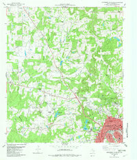
1982 Map of Northwest Palestine
USGS Topo · Published 1982About this map
The northwest corner of Palestine serves as the focal point for this 1982 study, where the expanding city limits meet the rural landscapes of Anderson County. Significant aviation and scientific infrastructure is evident at the Municipal Airport and the specialized National Scientific Balloon Facility, reflecting the area's modern technical contributions. The rail heritage of the region is well-represented by the Missouri Pacific lines and the Texas State RR, which pass through the southern portion of the map.
Find a feature on this map
55 named features on this map. Tap any name to fly to it.
Don’t see what you’re looking for? This feature index may not catch every label — zoom into the map to look around manually.
Map Details
Editions of this 1982 Northwest Palestine Map
This is the sole edition of this map. No revisions or reprints were ever made.
Other maps of this area

1949 · Palestine
USGS Topo · 1:62,500

1949 · Tennessee Colony
USGS Topo · 1:62,500

1950 · Palestine
USGS Topo · 1:62,500

1950 · Tennessee Colony
USGS Topo · 1:62,500

1951 · Elkhart
USGS Topo · 1:62,500

1953 · Palestine
USGS Topo · 1:250,000

1957 · Palestine
USGS Topo · 1:250,000

1964 · Long Lake
USGS Topo · 1:24,000

1981 · Palestine
USGS Topo · 1:100,000
1982 · Tennessee Colony
USGS Topo · 1:24,000