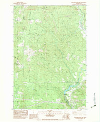
1983 Map of Northwestern Lake
USGS Topo · Published 1983About this map
The White Salmon River carves a deep path through this portion of the Monte Cristo Range, serving as the boundary between Skamania and Klickitat counties. In the early 1980s, this landscape was defined by its industrial and recreational utility within the Gifford Pinchot National Forest. A Concrete Dam on the river creates Northwestern Lake, while a surviving Lumber Flume downstream highlights the area's history of timber transport. High-elevation fire lookouts, including the Nestor Peak 3143T Look Out House and Little Baldy LOH, overlook the rugged drainages of Mill Creek and Buck Creek. The small settlement at B Z Corner and the Gilmer Substation provide the primary signs of permanent habitation amidst a network of 4WD tracks and forest campsites like Oklahoma Campground.
Find a feature on this map
34 named features on this map. Tap any name to fly to it.
Don’t see what you’re looking for? This feature index may not catch every label — zoom into the map to look around manually.
Map Details
Editions of this 1983 Northwestern Lake Map
This is the sole edition of this map. No revisions or reprints were ever made.
Other maps of this area

1926 · Hood River
USGS Topo · 1:125,000

1929 · Hood River
USGS Topo · 1:125,000

1934 · The Dalles
USGS Topo · 1:125,000

1953 · The Dalles
USGS Topo · 1:250,000

1956 · The Dalles
USGS Topo · 1:250,000

1957 · The Dalles
USGS Topo · 1:250,000

1957 · Willard
USGS Topo · 1:62,500

1957 · White Salmon
USGS Topo · 1:62,500

1957 · Husum
USGS Topo · 1:62,500

1957 · Hood River
USGS Topo · 1:62,500