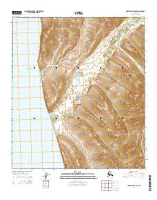
2014 Map of Norton Bay A-4 SW
USGS Topo · Published 2014About this map
Egavik stands as the primary coastal settlement on this portion of the Bering Sea shoreline, situated where the Egavik Road meets the coast. The landscape is defined by the immediate transition from the waters of Norton Sound to the upland terrain of the Unalakleet region. The local infrastructure reflects the remote nature of the area, consisting mainly of the Shaktolik Road which traverses the hills inland, and the riparian corridor created by Egavik Cr. This survey illustrates the relationship between small coastal outposts and the limited overland routes that connect them across the Alaskan tundra and coastal bluffs.
Find a feature on this map
9 named features on this map. Tap any name to fly to it.
Don’t see what you’re looking for? This feature index may not catch every label — zoom into the map to look around manually.
Map Details
Editions of this 2014 Norton Bay A-4 SW Map
This is the sole edition of this map. No revisions or reprints were ever made.
Other maps of this area

1948 · Norton Bay
USGS Topo · 1:250,000

1950 · Norton Bay A-4
USGS Topo · 1:63,360

1950 · Unalakleet D-4
USGS Topo · 1:63,360

1951 · Unalakleet
USGS Topo · 1:250,000

1951 · Norton Bay
USGS Topo · 1:250,000

1952 · Unalakleet
USGS Topo · 1:250,000

1955 · Norton Bay
USGS Topo · 1:250,000

1964 · Unalakleet
USGS Topo · 1:250,000
2014 · Norton Bay A-4 NW
USGS Topo · 1:25,000
2015 · Norton Bay A-4 SE
USGS Topo · 1:25,000