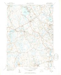
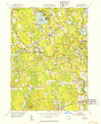
1951 Map of Norton
USGS Topo · Published 1953About this map
The Norton Reservoir and the Canoe River define the northern landscape of this Bristol County region, where industrial and educational institutions sit alongside extensive wetlands like the Hemlock Swamp. In the early 1950s, the New York New Haven and Hartford rail line remained a primary artery through Norton, connecting the manufacturing heritage of the Copper Works to the campus of Wheaton College. Further south, the map documents significant social infrastructure of the era, including the Myles Standish State School and the Colony State Hospital near Oakland.
Find a feature on this map
61 named features on this map. Tap any name to fly to it.
Don’t see what you’re looking for? This feature index may not catch every label — zoom into the map to look around manually.
Map Details
Editions of this 1951 Norton Map
3 editions found

Other maps of this area

1885 · Taunton
USGS Topo · 1:62,500

1886 · Dedham
USGS Topo · 1:62,500

1887 · Franklin
USGS Topo · 1:62,500

1887 · Providence
USGS Topo · 1:62,500

1888 · Taunton
USGS Topo · 1:62,500

1889 · Providence
USGS Topo · 1:62,500

1889 · Franklin
USGS Topo · 1:62,500

1893 · Taunton
USGS Topo · 1:62,500

1893 · Franklin
USGS Topo · 1:62,500

1894 · Dedham
USGS Topo · 1:62,500