
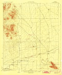
1929 Map of Norton
USGS Topo · Published 1929About this map
The Gila River corridor defines this arid landscape in the late 1920s, showing a vital lifeline of water and transport through the desert. Settlement is concentrated along the Southern Pacific railroad and the river, where small outposts like Norton and Growler served as key points for travel and trade. The presence of the Electric Gas and Water Co infrastructure and the Terry Ranch near Roll suggests the early development of utility networks and ranching in this corner of Yuma County. Away from the river, the terrain rises sharply into the Castle Dome Range and Mohawk Mountains, marked by isolated water sources such as Mesquite Jim Well and Indian Well. These features, connected by long desert tracks like the Kofa and Wellton Road, illustrate the difficult logistics of movement before modern highway systems.
Find a feature on this map
16 named features on this map. Tap any name to fly to it.
Don’t see what you’re looking for? This feature index may not catch every label — zoom into the map to look around manually.
Map Details
Editions of this 1929 Norton Map
2 editions found
Other maps of this area

1926 · Wellton
USGS Topo · 1:62,500

1926 · Mohawk
USGS Topo · 1:62,500

1927 · Kim
USGS Topo · 1:62,500

1928 · Mohawk
USGS Topo · 1:62,500

1928 · Norton
USGS Topo · 1:62,500

1929 · Wellton
USGS Topo · 1:62,500

1930 · Stoval
USGS Topo · 1:62,500

1931 · Kim
USGS Topo · 1:62,500

1942 · Yuma
USGS Topo · 1:250,000

1942 · Blythe
USGS Topo · 1:250,000