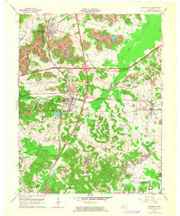
1963 Map of Nortonville
USGS Topo · Published 1964About this map
Nortonville stands as a central rail junction in this early 1960s study of western Kentucky, where the north-south Louisville and Nashville and east-west Illinois Central lines intersect. The landscape is defined by its industrial output, with extensive Strip Mines and numerous Oil Wells peppered across the terrain. Small communities like Mortons Gap and White Plains are clearly detailed, alongside significant local landmarks such as South Hopkins Sch and Nortonville Lake.
Find a feature on this map
45 named features on this map. Tap any name to fly to it.
Don’t see what you’re looking for? This feature index may not catch every label — zoom into the map to look around manually.
Map Details
Editions of this 1963 Nortonville Map
This is the sole edition of this map. No revisions or reprints were ever made.
Other maps of this area

1907 · Earlington
USGS Topo · 1:48,000

1909 · Dawson Springs
USGS Topo · 1:48,000

1909 · Earlington
USGS Topo · 1:62,500

1909 · Madisonville
USGS Topo · 1:62,500

1911 · Dawson Springs
USGS Topo · 1:62,500

1912 · Nortonville
USGS Topo · 1:62,500

1952 · Crofton
USGS Topo · 1:24,000

1953 · Dawson Springs SE
USGS Topo · 1:24,000

1953 · Haleys Mill
USGS Topo · 1:24,000

1953 · Nortonville
USGS Topo · 1:24,000