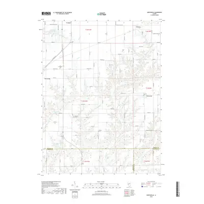
2018 Map of Nortonville
USGS Topo · Published 2018About this map
Nortonville and the surrounding farmland of central Illinois sit at the intersection of Morgan, Greene, and Macoupin counties in this recent survey. The landscape is defined by the winding paths of Apple Cr and its tributaries, including Little Apple Cr and Mooney Br, which cut through the agricultural grid. For local historians, the map is remarkably dense with family and community landmarks, particularly small cemeteries that anchor the rural landscape. From the Youngblood Cem near the heart of Nortonville to the Whitlock Cem and Zion Number One Cem further south, these sites offer a clear record of the area's ancestral settlements. The northern reaches show the proximity of Woodson and the Murrayville Woodson Lake, while the southern border tracks the transition into Greene County near the Ceres Cem.
Find a feature on this map
91 named features on this map. Tap any name to fly to it.
Don’t see what you’re looking for? This feature index may not catch every label — zoom into the map to look around manually.
Map Details
Editions of this 2018 Nortonville Map
This is the sole edition of this map. No revisions or reprints were ever made.
Other maps of this area

1924 · Winchester
USGS Topo · 1:48,000

1924 · Roodhouse
USGS Topo · 1:62,500

1926 · Winchester
USGS Topo · 1:62,500

1926 · Roodhouse
USGS Topo · 1:62,500

1932 · Greenfield
USGS Topo · 1:62,500

1932 · Jacksonville
USGS Topo · 1:62,500

1937 · Jacksonville
USGS Topo · 1:62,500

1948 · Quincy
USGS Topo · 1:250,000

1956 · Quincy
USGS Topo · 1:250,000
1983 · Manchester
USGS Topo · 1:24,000