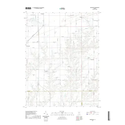
2021 Map of Nortonville
USGS Topo · Published 2021About this map
The agricultural landscape of Nortonville and Murrayville sits at the meeting point of Morgan, Greene, and Macoupin Counties. This 2021 survey reveals a territory defined by its rural history, where family-named cemeteries such as Youngblood Cem and Whitlock Cem are scattered across the section lines. The drainage pattern of Apple Creek and its various branches, including the Left Fork Apple Creek, carves through the central and southern portions of the map, creating a distinct topographical contrast to the flatter northern reaches around Woodson. Local heritage is anchored by landmarks like Zion Number One Cemetery and Saint Bartholomew Cemetery, while industrial and logistical hubs like Clements and the Ware Brothers Pond highlight the ongoing land use in this part of Illinois.
Find a feature on this map
82 named features on this map. Tap any name to fly to it.
Don’t see what you’re looking for? This feature index may not catch every label — zoom into the map to look around manually.
Map Details
Editions of this 2021 Nortonville Map
This is the sole edition of this map. No revisions or reprints were ever made.
Other maps of this area

1924 · Winchester
USGS Topo · 1:48,000

1924 · Roodhouse
USGS Topo · 1:62,500

1926 · Winchester
USGS Topo · 1:62,500

1926 · Roodhouse
USGS Topo · 1:62,500

1932 · Greenfield
USGS Topo · 1:62,500

1932 · Jacksonville
USGS Topo · 1:62,500

1937 · Jacksonville
USGS Topo · 1:62,500

1948 · Quincy
USGS Topo · 1:250,000

1956 · Quincy
USGS Topo · 1:250,000
1983 · Manchester
USGS Topo · 1:24,000