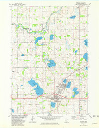
1981 Map of Norwood
USGS Topo · Published 1982About this map
Young America and Norwood anchor this survey of central Carver County, appearing as distinct but adjacent settlements before their eventual consolidation. The landscape is defined by the winding course of the Crow River South Fork and a dense network of glacial basins, including Tiger Lake, Baylor Lake, and Young America Lake. This era shows the heavy influence of rail transport on local geography, with the Chicago Milwaukee St Paul and Pacific and the Chicago and North Western lines intersecting near the town centers.
Find a feature on this map
35 named features on this map. Tap any name to fly to it.
Don’t see what you’re looking for? This feature index may not catch every label — zoom into the map to look around manually.
Map Details
Editions of this 1981 Norwood Map
This is the sole edition of this map. No revisions or reprints were ever made.
Other maps of this area

1953 · Saint Paul
USGS Topo · 1:250,000

1953 · New Ulm
USGS Topo · 1:250,000

1957 · New Ulm
USGS Topo · 1:250,000

1957 · Belle Plaine
USGS Topo · 1:62,500

1957 · Waconia
USGS Topo · 1:62,500

1958 · New Ulm
USGS Topo · 1:250,000

1958 · Gaylord
USGS Topo · 1:62,500

1958 · Glencoe
USGS Topo · 1:62,500

1959 · Saint Paul
USGS Topo · 1:250,000

1967 · New Ulm
USGS Topo · 1:250,000
Featured Places
- Norwood Young America, MN
- Young America, Norwood Young America
- Waconia Township, MN
- Young America Township, MN
- Benton Township, MN