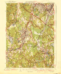
1941 Map of Norwood
USGS Topo · Published 1941About this map
Norwood and its neighbors in the Neponset River valley are shown here just before the mid-century suburban expansion, characterized by a mix of industrial centers and significant institutional landscapes. The New York New Haven And Hartford RR serves as the primary artery for the region, connecting the major hubs of Walpole and Canton to the growing residential districts of Hyde Park and East Dedham. The map reveals a dense network of local-history interest, from the Colburn Sch in Westwood to the sprawling Sharon Sanitorium near the southern boundary. Significant green spaces like the Blue Hills Reservation and the extensive marshlands of Fowl Meadow contrast with the developing town centers and the Circumferential Highway corridor. Genealogists can locate numerous burial grounds, including the Highland Cem and Fairview Cemetery, which anchor the various community boundaries of this Massachusetts industrial corridor.
Find a feature on this map
69 named features on this map. Tap any name to fly to it.
Don’t see what you’re looking for? This feature index may not catch every label — zoom into the map to look around manually.
Map Details
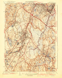
Editions of this 1941 Norwood Map
3 editions found

Other maps of this area

1886 · Dedham
USGS Topo · 1:62,500

1886 · Framingham
USGS Topo · 1:62,500

1887 · Franklin
USGS Topo · 1:62,500

1889 · Franklin
USGS Topo · 1:62,500

1889 · Framingham
USGS Topo · 1:62,500

1893 · Franklin
USGS Topo · 1:62,500

1893 · Boston
USGS Topo · 1:62,500

1894 · Dedham
USGS Topo · 1:62,500

1894 · Framingham
USGS Topo · 1:62,500

1903 · Boston
USGS Topo · 1:62,500