1958 Map of Norwood
USGS Topo · Published 1960About this map
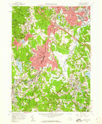
The Neponset River carves a path through the heart of the Norfolk County landscape, anchoring a corridor of industry and aviation in the late 1950s. The bustling center of Norwood is clearly defined, showing the proximity of the Norwood Memorial Airport and the Norwood Arena to the town's core. Civic life is well-documented with the Morrill Mem Library, the Court House, and numerous schools like the Ames Jr High Sch.
Find a feature on this map
115 named features on this map. Tap any name to fly to it.
Don’t see what you’re looking for? This feature index may not catch every label — zoom into the map to look around manually.
Map Details
Editions of this 1958 Norwood Map
2 editions found

Other maps of this area

1886 · Dedham
USGS Topo · 1:62,500

1886 · Framingham
USGS Topo · 1:62,500

1887 · Franklin
USGS Topo · 1:62,500

1889 · Franklin
USGS Topo · 1:62,500

1889 · Framingham
USGS Topo · 1:62,500

1893 · Franklin
USGS Topo · 1:62,500

1893 · Boston
USGS Topo · 1:62,500

1894 · Dedham
USGS Topo · 1:62,500

1894 · Framingham
USGS Topo · 1:62,500

1903 · Boston
USGS Topo · 1:62,500