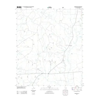
2013 Map of Norwood
USGS Topo · Published 2013About this map
Norwood and Macune anchor this area of San Augustine County, where the landscape is defined by a dense network of creek branches and drainages. The eastern portion of the survey is dominated by the winding course of Ayish Bayou, which is fed by numerous tributaries including Black Slough and Hardikner Cr. This 2013 record illustrates the rural character of East Texas, showing a high concentration of family and community burial grounds such as Maryland Cem, Miller Cem, and Farrar Cem tucked away from the main thoroughfares. Transportation is centered on rural routes like FM 1277 and FM 705, which connect these small settlements across the undulating terrain. The names of the watercourses, from School Br to Steptoe Br, suggest a long history of local land use and geographic naming conventions that have persisted into the twenty-first century.
Find a feature on this map
42 named features on this map. Tap any name to fly to it.
Don’t see what you’re looking for? This feature index may not catch every label — zoom into the map to look around manually.
Map Details
Editions of this 2013 Norwood Map
This is the sole edition of this map. No revisions or reprints were ever made.
Other maps of this area

1953 · Palestine
USGS Topo · 1:250,000

1957 · Palestine
USGS Topo · 1:250,000

1958 · Broaddus
USGS Topo · 1:62,500

1958 · San Augustine
USGS Topo · 1:62,500

1958 · Martinsville
USGS Topo · 1:62,500

1958 · Bronson
USGS Topo · 1:62,500

1984 · Norwood
USGS Topo · 1:24,000
1984 · Chireno South
USGS Topo · 1:24,000
1984 · Harvey Creek
USGS Topo · 1:24,000
1984 · Chinquapin
USGS Topo · 1:24,000