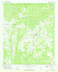
1971 Map of Notasulga
USGS Topo · Published 1973About this map
Notasulga serves as the central hub of this 1971 survey, situated at the junction of the Western Railway of Alabama and several rural roads. The landscape is defined by its deep spiritual and educational roots, featuring numerous country churches like Lockets Chapel, Antioch Church, and St John Church, along with the Notasulga High School. The terrain is drained by the winding Sougahatchee Creek to the north and Wolf Creek to the west, where industrial activity is noted at McRitchie Mill and various Quarries.
Find a feature on this map
29 named features on this map. Tap any name to fly to it.
Don’t see what you’re looking for? This feature index may not catch every label — zoom into the map to look around manually.
Map Details
Editions of this 1971 Notasulga Map
2 editions found
Other maps of this area

1906 · Dadeville
USGS Topo · 1:125,000

1955 · Phenix City
USGS Topo · 1:250,000

1957 · Phenix City
USGS Topo · 1:250,000

1958 · Phenix City
USGS Topo · 1:250,000

1971 · Waverly
USGS Topo · 1:24,000

1971 · Ponders
USGS Topo · 1:24,000

1971 · Little Texas
USGS Topo · 1:24,000

1971 · Carrville
USGS Topo · 1:24,000

1971 · Loachapoka
USGS Topo · 1:24,000

1971 · Tuskegee
USGS Topo · 1:24,000