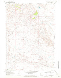
1968 Map of Notches Dome
USGS Topo · Published 1972About this map
Notches Dome dominates this Natrona County landscape, serving as the central geologic feature in a territory defined by resource extraction and livestock movement. By the late 1960s, the Oil Field at the heart of the dome was supported by a network of industrial infrastructure, including numerous Drill Holes, a Flowing Well, and the Notches Road. The survey reveals a landscape adapted for high-desert utility, where the Cottonwood Stock Trail and Lester Road Trail cross arid expanses like Ralston Flats and Cactus Flat. Significant drainage systems such as Okie Draw and Cave Gulch carve through the terrain, while Lester Lake provides a rare water source in the northern reaches. This document is a precise record of Wyoming's mid-century petroleum development and the enduring paths used by ranching operations.
Find a feature on this map
19 named features on this map. Tap any name to fly to it.
Don’t see what you’re looking for? This feature index may not catch every label — zoom into the map to look around manually.
Map Details
Editions of this 1968 Notches Dome Map
This is the sole edition of this map. No revisions or reprints were ever made.
Other maps of this area

1952 · Deadman Butte
USGS Topo · 1:24,000

1952 · Waltman NW
USGS Topo · 1:24,000

1952 · Waltman
USGS Topo · 1:24,000

1955 · Arminto
USGS Topo · 1:250,000

1958 · Arminto
USGS Topo · 1:250,000

1962 · Arminto
USGS Topo · 1:250,000

1968 · Flat Top Hill
USGS Topo · 1:24,000
1968 · Powder River
USGS Topo · 1:24,000
1968 · Three Buttes
USGS Topo · 1:24,000
1968 · Cave Gulch Reservoir
USGS Topo · 1:24,000