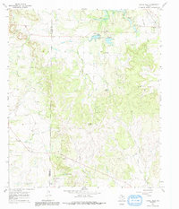
1967 Map of Novice West
USGS Topo · Published 1991About this map
The border between Runnels and Coleman counties divides this West Texas landscape, where the small settlement of Novice sits near the headwaters of the South Fork Jim Ned Creek. In the late 1960s, the local economy was anchored by the Williams Oil Field and numerous scattered wells throughout the eastern half of the quadrangle. Water management is a defining characteristic of the terrain, visible in the infrastructure of Novice City Lake with its three distinct spillways and the seasonal flow of Hords Creek and Mud Creek. Genealogists will find the rural burial grounds at Atoka Cem and Crews Cem preserved in their mid-century context, while several named water sources like Jim Ned Spring and Pecan Spring suggest the importance of reliable water in this rolling ranch and oil country. Topographically, the area is punctuated by Gap and Blue Gap, which overlook the complex network of draws and prongs feeding the regional creek systems.
Find a feature on this map
27 named features on this map. Tap any name to fly to it.
Don’t see what you’re looking for? This feature index may not catch every label — zoom into the map to look around manually.
Map Details
Editions of this 1967 Novice West Map
2 editions found
Other maps of this area

1890 · Abilene
USGS Topo · 1:125,000

1892 · Abilene
USGS Topo · 1:125,000

1892 · Ballinger
USGS Topo · 1:125,000

1954 · Brownwood
USGS Topo · 1:250,000

1954 · Abilene
USGS Topo · 1:250,000

1958 · Abilene
USGS Topo · 1:250,000

1967 · Talpa
USGS Topo · 1:24,000

1967 · Novice West
USGS Topo · 1:24,000
1967 · Novice East
USGS Topo · 1:24,000
1967 · Valera
USGS Topo · 1:24,000