
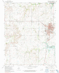
1972 Map of Nowata West
USGS Topo · Published 1974About this map
Nowata sits at the eastern edge of this landscape, its residential grid defined by streets like Shawnee Ave and Seneca Ave. The area west of the town center transitions into a patchwork of rural gathering places and oil exploration. Significant local landmarks include the Diamond Point Community Hall and Elm Bend Community Hall, which serve as anchors for the surrounding countryside. This 1972 topography captures the region as the waters of Oologah Lake begin to influence the drainage of local tributaries like Double Creek and Mormon Creek. The Missouri Pacific railroad cuts a straight north-south line through the terrain, passing the Nowata Municipal Airport and connecting the town to the broader industrial network. Traces of the region's mineral wealth are evident in the numerous oil wells and drill holes scattered across the creek-fed valleys.
Find a feature on this map
46 named features on this map. Tap any name to fly to it.
Don’t see what you’re looking for? This feature index may not catch every label — zoom into the map to look around manually.
Map Details
Editions of this 1972 Nowata West Map
2 editions found
Other maps of this area

1901 · Nowata
USGS Topo · 1:125,000

1914 · Nowata
USGS Topo · 1:125,000

1954 · Tulsa
USGS Topo · 1:250,000

1958 · Tulsa
USGS Topo · 1:250,000

1963 · Tulsa
USGS Topo · 1:250,000

1970 · Bartlesville SE
USGS Topo · 1:24,000
1970 · Talala
USGS Topo · 1:24,000
1970 · Winganon
USGS Topo · 1:24,000

1972 · Blue Mound
USGS Topo · 1:24,000
1972 · Delaware
USGS Topo · 1:24,000