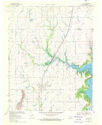
1970 Map of Talala
USGS Topo · Published 1972About this map
Talala serves as the primary hub of this Rogers County landscape, situated along the Missouri Pacific railroad line. The map illustrates a transitional period for the local geography as the rising waters of the Oologah Reservoir reshape the eastern and southern edges of the quadrangle. This inundation affects the lower reaches of Talala Creek and Fourmile Creek, creating a complex new shoreline where previously there was only river bottomland. To the north, the small settlement of Watova sits near the border of Nowata County, connected to the southern townships by the same rail corridor and a network of section-line roads. Local history is anchored by features such as Fair View Cem and several industrial Sandpit operations, providing a detailed record of the community's footprint before the full impact of the reservoir was realized.
Find a feature on this map
15 named features on this map. Tap any name to fly to it.
Don’t see what you’re looking for? This feature index may not catch every label — zoom into the map to look around manually.
Map Details
Editions of this 1970 Talala Map
This is the sole edition of this map. No revisions or reprints were ever made.
Other maps of this area

1901 · Claremore
USGS Topo · 1:125,000

1901 · Nowata
USGS Topo · 1:125,000

1914 · Nowata
USGS Topo · 1:125,000

1914 · Claremore
USGS Topo · 1:125,000

1916 · Claremore
USGS Topo · 1:125,000

1954 · Tulsa
USGS Topo · 1:250,000

1958 · Tulsa
USGS Topo · 1:250,000

1959 · Collinsville NE
USGS Topo · 1:24,000

1963 · Tulsa
USGS Topo · 1:250,000

1970 · Bartlesville SE
USGS Topo · 1:24,000