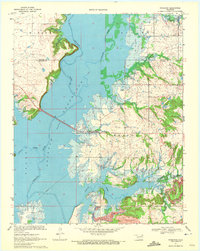
1970 Map of Winganon
USGS Topo · Published 1972About this map
Oologah Reservoir dominates the western half of this 1970 study, which captures the Rogers and Nowata county line as the regional landscape was being reshaped by large-scale water management. The inundation of the Verdigris River valley is clearly shown, with a long causeway carrying a roadway across the water at an elevation of 638 feet. The settlement of Winganon sits on the eastern shore, serving as a focal point for local history along with the nearby Winganon Cem and a Church of Christ.
Find a feature on this map
26 named features on this map. Tap any name to fly to it.
Don’t see what you’re looking for? This feature index may not catch every label — zoom into the map to look around manually.
Map Details
Editions of this 1970 Winganon Map
This is the sole edition of this map. No revisions or reprints were ever made.
Other maps of this area

1896 · Pryor
USGS Topo · 1:125,000

1901 · Claremore
USGS Topo · 1:125,000

1901 · Nowata
USGS Topo · 1:125,000

1901 · Vinita
USGS Topo · 1:125,000

1901 · Pryor
USGS Topo · 1:125,000

1913 · Vinita
USGS Topo · 1:125,000

1914 · Nowata
USGS Topo · 1:125,000

1914 · Claremore
USGS Topo · 1:125,000

1916 · Claremore
USGS Topo · 1:125,000

1954 · Tulsa
USGS Topo · 1:250,000