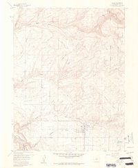
1960 Map of Nucla
USGS Topo · Published 1961About this map
Nucla serves as the central hub on this landscape, established as a cooperative agricultural colony on the plateau. The map details the transition from the high Uncompahgre National Forest in the east, characterized by Pinto Mesa, down into the deep drainage systems of the San Miguel River. Mining activity is a dominant feature of the local economy during this era, with numerous operations such as the Navajo Mine, Oberding Mine, and USV Mine scattered across the high desert terrain. Local infrastructure is anchored by the Nucla Cem and the High Sch, while the intricate network of water management is evidenced by the Town Reservoir and various pipe lines. The rugged north-central portion is marked by extensive canyons, including Doby Canyon and Coal Canyon, where old pack trails and jeep trails provide the primary means of traversal through the rocky breaks.
Find a feature on this map
37 named features on this map. Tap any name to fly to it.
Don’t see what you’re looking for? This feature index may not catch every label — zoom into the map to look around manually.
Map Details
Editions of this 1960 Nucla Map
3 editions found
Other maps of this area

1916 · Paradox Valley
USGS Topo · 1:125,000

1922 · Paradox Valley
USGS Topo · 1:125,000

1948 · Uravan
USGS Topo · 1:24,000

1948 · Naturita NW
USGS Topo · 1:24,000

1949 · Uravan
USGS Topo · 1:24,000

1949 · Naturita NW
USGS Topo · 1:24,000

1949 · Atkinson Creek
USGS Topo · 1:24,000

1950 · Atkinson Creek
USGS Topo · 1:24,000

1956 · Moab
USGS Topo · 1:250,000

1959 · Moab
USGS Topo · 1:250,000