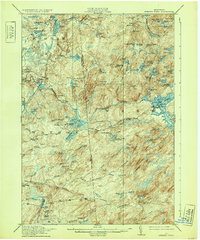
1915 Map of Number Four
USGS Topo · Published 1932About this map
Number Four serves as a central landmark in this high Adirondack wilderness surveyed shortly before the First World War. The landscape is defined by the complex hydrology of the Oswegatchie River and its branches, alongside a dense network of glacial ponds such as Raven Lake, Gregg Lake, and Tied Lake. Evidence of early resource management and industry appears in the form of remote infrastructure like Beech Dam and the Silver Mine Dam near the southern boundary. Significant elevations like Stillwater Mtn and Peaked Mtn rise above the wetlands and flats, including the prominent Balsam Flats. This era of the New York woods shows a transition from pure wilderness to a managed forest, where the early 20th-century surveyors meticulously documented every stream crossing and remote peak, from Mt Tom to Buck Mtn.
Find a feature on this map
98 named features on this map. Tap any name to fly to it.
Don’t see what you’re looking for? This feature index may not catch every label — zoom into the map to look around manually.
Map Details
Editions of this 1915 Number Four Map
5 editions found
Other maps of this area

1901 · Old Forge
USGS Topo · 1:62,500

1903 · Big Moose
USGS Topo · 1:62,500

1905 · Port Leyden
USGS Topo · 1:62,500

1907 · Port Leyden
USGS Topo · 1:62,500

1911 · Lowville
USGS Topo · 1:62,500

1912 · Number Four
USGS Topo · 1:62,500

1912 · Mc Keever
USGS Topo · 1:62,500

1913 · Lowville
USGS Topo · 1:62,500

1913 · Lake Bonaparte
USGS Topo · 1:62,500

1915 · Number Four
USGS Topo · 1:62,500