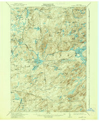
1915 Map of Number Four
USGS Topo · Published 1938About this map
The remote settlement of Number Four serves as the central hub of this wilderness landscape, situated at the crossroads of the Watson and New Bremen township lines. Surveyed shortly before the Great War and reprinted in the late 1930s, the map reveals an intricate network of Adirondack hydrology, from the northern Oswegatchie River to the southern reaches of the Independence River. The development of local water resources is evident through landmarks like the Soft Maple Dam and Silver Mine Dam, while the Sunday Creek Reservoir marks a significant alteration to the natural drainage. This interior region, spanning the Lewis and Herkimer County line, is defined by its glacial features, including the prominent Hogs Back ridge and dozens of isolated water bodies such as Francis Lake and Crooked Lake. The terrain rises sharply toward Stillwater Mtn and Mt Tom, illustrating the transition from swampy lowlands to high woodland peaks.
Find a feature on this map
99 named features on this map. Tap any name to fly to it.
Don’t see what you’re looking for? This feature index may not catch every label — zoom into the map to look around manually.
Map Details
Editions of this 1915 Number Four Map
5 editions found
Other maps of this area

1901 · Old Forge
USGS Topo · 1:62,500

1903 · Big Moose
USGS Topo · 1:62,500

1905 · Port Leyden
USGS Topo · 1:62,500

1907 · Port Leyden
USGS Topo · 1:62,500

1911 · Lowville
USGS Topo · 1:62,500

1912 · Number Four
USGS Topo · 1:62,500

1912 · Mc Keever
USGS Topo · 1:62,500

1913 · Lowville
USGS Topo · 1:62,500

1913 · Lake Bonaparte
USGS Topo · 1:62,500

1915 · Number Four
USGS Topo · 1:62,500