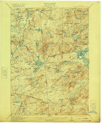
1915 Map of Number Four
USGS Topo · Published 1921About this map
Number Four serves as the primary outpost in this densely wooded portion of the Adirondacks during the early twentieth century. The landscape is defined by the intricate hydrological networks of the Oswegatchie River and its middle branch, alongside the Beaver River and Independence River. This survey captures the transition of the wilderness as hydraulic engineering began to reshape the waterways, evidenced by structures such as the Soft Maple Dam, Beech Dam, and Silver Mine Dam.
Find a feature on this map
103 named features on this map. Tap any name to fly to it.
Don’t see what you’re looking for? This feature index may not catch every label — zoom into the map to look around manually.
Map Details
Editions of this 1915 Number Four Map
5 editions found
Other maps of this area

1901 · Old Forge
USGS Topo · 1:62,500

1903 · Big Moose
USGS Topo · 1:62,500

1905 · Port Leyden
USGS Topo · 1:62,500

1907 · Port Leyden
USGS Topo · 1:62,500

1911 · Lowville
USGS Topo · 1:62,500

1912 · Number Four
USGS Topo · 1:62,500

1912 · Mc Keever
USGS Topo · 1:62,500

1913 · Lowville
USGS Topo · 1:62,500

1913 · Lake Bonaparte
USGS Topo · 1:62,500

1915 · Number Four
USGS Topo · 1:62,500