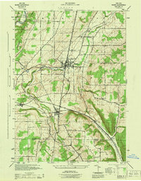
1944 Map of Nunda
USGS Topo · Published 1944About this map
Nunda stands as the central hub of this mid-century landscape, where the confluence of agriculture and rail transport is clearly mapped. The village is surrounded by a network of smaller communities such as Oakland, Hunts Hollow, and Dalton, many of which were defined by their proximity to the Pennsylvania RR and Erie RR railroads. The topography is dominated by the deeply carved valley of Keshequa Cr, which winds through the townships of Nunda and Portage. In the northwest, the edge of Letchworth State Park borders the Genesee River, marking a transition from the structured farm tracts of the interior to the dramatic river gorge. This survey, prepared by the War Department during the final years of World War II, provides a precise look at local family roads like Pickett Lane and Oakland Road before the era of modern highway expansion changed the scale of these rural connections.
Find a feature on this map
28 named features on this map. Tap any name to fly to it.
Don’t see what you’re looking for? This feature index may not catch every label — zoom into the map to look around manually.
Map Details
Editions of this 1944 Nunda Map
This is the sole edition of this map. No revisions or reprints were ever made.
Other maps of this area

1905 · Portage
USGS Topo · 1:62,500

1905 · Nunda
USGS Topo · 1:62,500

1906 · Angelica
USGS Topo · 1:62,500

1916 · Canaseraga
USGS Topo · 1:62,500

1940 · Canaseraga
USGS Topo · 1:62,500

1941 · Angelica
USGS Topo · 1:62,500

1943 · Mount Morris
USGS Topo · 1:24,000

1943 · Sonyea
USGS Topo · 1:24,000

1943 · Nunda
USGS Topo · 1:24,000

1943 · Ossian
USGS Topo · 1:24,000