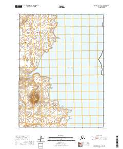
2020 Map of Nunivak Island A-2 SW
USGS Topo · Published 2020About this map
Nunivak Island meets the Bering Sea along this coastal stretch of the Bethel Census Area. The topography is defined by the prominent volcanic profile of Twin Mtn, which rises above a landscape of scattered tundra ponds and wetlands. This 2020 survey documents a largely maritime environment where the land transitions into the sea at Little Cape Corwin. The map provides precise detail of the shoreline and elevation contours, illustrating the geological character of the island's eastern coast within the townships of t1s r96w, t1s r95w, t2s r96w, and t2s r95w.
Find a feature on this map
8 named features on this map. Tap any name to fly to it.
Don’t see what you’re looking for? This feature index may not catch every label — zoom into the map to look around manually.
Map Details
Editions of this 2020 Nunivak Island A-2 SW Map
This is the sole edition of this map. No revisions or reprints were ever made.
Other maps of this area

1951 · Cape Mendenhall
USGS Topo · 1:250,000

1951 · Nunivak Island
USGS Topo · 1:250,000

1952 · Cape Mendenhall D-3
USGS Topo · 1:63,360

1952 · Cape Mendenhall
USGS Topo · 1:250,000
1952 · Cape Mendenhall D-2
USGS Topo · 1:63,360

1952 · Nunivak Island A-3
USGS Topo · 1:63,360
1952 · Nunivak Island A-2
USGS Topo · 1:63,360

1954 · Nunivak Island
USGS Topo · 1:250,000

1958 · Nunivak Island
USGS Topo · 1:250,000

1964 · Nunivak Island
USGS Topo · 1:250,000