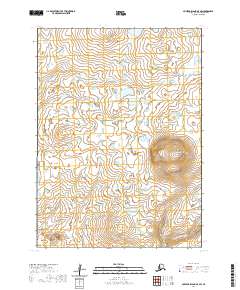
2020 Map of Nunivak Island A-5 SW
USGS Topo · Published 2020About this map
The Kiyakyaliksamiut River winds through this section of Nunivak Island, defining a landscape dominated by complex hydrological patterns and volcanic topography. This area of the Bethel Census Area is characterized by its network of water bodies, including the Chakwakamiut River and Antingamiut Cr, which drain the low-lying wetlands. Prominent landmarks such as Kikdooli Butte and Kikolrodik Hill rise above the surrounding terrain, providing crucial orientation points in a region largely defined by its natural watercourses and lack of modern infrastructure. The map detail reflects the persistence of traditional Indigenous place names across the island's interior, preserved through the 1981-2009 Geographic Names Information System data.
Find a feature on this map
9 named features on this map. Tap any name to fly to it.
Don’t see what you’re looking for? This feature index may not catch every label — zoom into the map to look around manually.
Map Details
Editions of this 2020 Nunivak Island A-5 SW Map
This is the sole edition of this map. No revisions or reprints were ever made.
Other maps of this area

1951 · Cape Mendenhall
USGS Topo · 1:250,000

1951 · Nunivak Island
USGS Topo · 1:250,000

1952 · Cape Mendenhall
USGS Topo · 1:250,000

1952 · Cape Mendenhall D-6
USGS Topo · 1:63,360

1952 · Nunivak Island A-6
USGS Topo · 1:63,360

1952 · Nunivak Island A-5
USGS Topo · 1:63,360
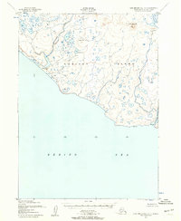
1952 · Cape Mendenhall D-5
USGS Topo · 1:63,360

1954 · Nunivak Island
USGS Topo · 1:250,000

1958 · Nunivak Island
USGS Topo · 1:250,000

1964 · Nunivak Island
USGS Topo · 1:250,000