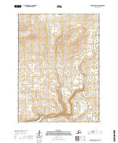
2020 Map of Nunivak Island A-6 SE
USGS Topo · Published 2020About this map
Kiyakyaliksamut River meanders across the southern and eastern reaches of this Bering Sea island landscape, defining a terrain shaped by tundra wetlands and volcanic rises. Two prominent topographic landmarks, Jiskooksnuk Hill and Kimiksthek Hill, dominate the northern half of the quadrangle, serving as essential reference points in an area largely devoid of permanent human settlements or infrastructure. The map illustrates the island’s characteristic drainage patterns, where small lakes and ponds collect in the low-lying areas between these higher elevations. This data represents the island's geography as documented by the U.S. Geological Survey using imagery from 2009 and hydrography updated through 2018, providing a precise record of the landforms and waterways within the Bethel Census Area before any further natural shifts in the subarctic environment.
Find a feature on this map
7 named features on this map. Tap any name to fly to it.
Don’t see what you’re looking for? This feature index may not catch every label — zoom into the map to look around manually.
Map Details
Editions of this 2020 Nunivak Island A-6 SE Map
This is the sole edition of this map. No revisions or reprints were ever made.
Other maps of this area

1951 · Cape Mendenhall
USGS Topo · 1:250,000

1951 · Nunivak Island
USGS Topo · 1:250,000

1952 · Cape Mendenhall
USGS Topo · 1:250,000

1952 · Cape Mendenhall D-6
USGS Topo · 1:63,360

1952 · Nunivak Island A-6
USGS Topo · 1:63,360

1952 · Nunivak Island A-5
USGS Topo · 1:63,360
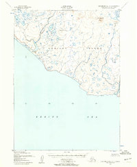
1952 · Cape Mendenhall D-5
USGS Topo · 1:63,360

1954 · Nunivak Island
USGS Topo · 1:250,000

1958 · Nunivak Island
USGS Topo · 1:250,000

1964 · Nunivak Island
USGS Topo · 1:250,000