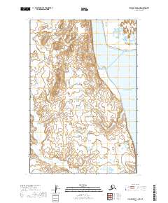
2019 Map of Nushagak Bay C-3 NW
USGS Topo · Published 2019About this map
Igushik sits at the edge of the wetlands along the Igushik River, serving as a central point in this coastal Alaskan landscape. The terrain is defined by the elevation of Igushik Ridge, which rises above the surrounding marshlands and the broad expanse of Nushagak Bay. The drainage patterns are clearly marked by the Tunuing River as it meanders through the low-lying interior toward the coast. This 2019 survey documents a region where settlement is sparse and dictated by the tidal influence and the navigable waters of the bay, illustrating how the natural geography continues to shape human presence and transport in the Dillingham Census Area.
Find a feature on this map
11 named features on this map. Tap any name to fly to it.
Don’t see what you’re looking for? This feature index may not catch every label — zoom into the map to look around manually.
Map Details
Editions of this 2019 Nushagak Bay C-3 NW Map
This is the sole edition of this map. No revisions or reprints were ever made.
Other maps of this area

1945 · Nushagak Bay
USGS Topo · 1:250,000

1948 · Nushagak Bay D-4
USGS Topo · 1:63,360

1948 · Nushagak Bay D-3
USGS Topo · 1:63,360

1948 · Nushagak Bay C-4 And C-5
USGS Topo · 1:63,360

1949 · Nushagak Bay
USGS Topo · 1:250,000

1950 · Nushagak Bay C-3
USGS Topo · 1:63,360

1950 · Nushagak Bay C-4 And C-5
USGS Topo · 1:63,360

1951 · Nushagak Bay
USGS Topo · 1:250,000

1952 · Nushagak Bay D-3
USGS Topo · 1:63,360

1952 · Nushagak Bay D-4
USGS Topo · 1:63,360