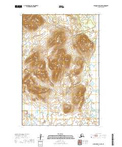
2019 Map of Nushagak Bay D-4 NW
USGS Topo · Published 2019About this map
Tuklung River meanders across the southern landscape of this Dillingham Census Area region, defining the primary drainage for the area. The terrain is characterized by significant topographic relief, with several prominent hills and ridges reaching elevations well above the surrounding wetland basins. Located within the t14s r60w and t15s r60w survey townships, the map documents a largely undeveloped wilderness where natural contours and water systems remain the dominant features. The lack of infrastructure or established settlements at the time of this 2019 survey emphasizes the isolation of this corner of Alaska, making it a critical record for understanding the original land forms and hydrography near Nushagak Bay before any modern encroachment.
Find a feature on this map
7 named features on this map. Tap any name to fly to it.
Don’t see what you’re looking for? This feature index may not catch every label — zoom into the map to look around manually.
Map Details
Editions of this 2019 Nushagak Bay D-4 NW Map
This is the sole edition of this map. No revisions or reprints were ever made.
Other maps of this area

1945 · Nushagak Bay
USGS Topo · 1:250,000

1948 · Nushagak Bay D-4
USGS Topo · 1:63,360

1949 · Nushagak Bay
USGS Topo · 1:250,000

1950 · Nushagak Bay D-5
USGS Topo · 1:63,360

1951 · Goodnews
USGS Topo · 1:250,000

1951 · Nushagak Bay
USGS Topo · 1:250,000

1952 · Nushagak Bay D-4
USGS Topo · 1:63,360

1964 · Nushagak Bay
USGS Topo · 1:250,000
1979 · Goodnews Bay A-1
USGS Topo · 1:63,360

1979 · Goodnews Bay
USGS Topo · 1:250,000