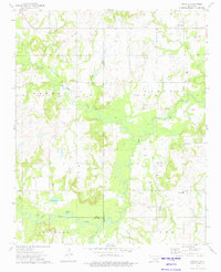
1973 Map of Nuyaka
USGS Topo · Published 1975About this map
Nuyaka and the winding Deep Fork define this portion of the Oklahoma landscape, where the convergence of Creek, Okmulgee, and Okfuskee counties meets a terrain heavily marked by the petroleum industry. Numerous Oil Field designations and scattered Oil Wells populate the hillsides, illustrating the region's mid-century economic focus. Historical transport routes are visible through the Old Railroad Grade, which once facilitated the movement of goods through the valley. Local genealogy is well-represented by several community anchors, including the Tuskegee Ch and its namesake Tuskegee Cem, alongside Dentonville and Edna. The bottomlands near the Deep Fork are dotted with water bodies like Sawmill Lake and Brushy Lake, reflecting a bottomland environment that remains largely rural and undeveloped outside of the extraction sites.
Find a feature on this map
39 named features on this map. Tap any name to fly to it.
Don’t see what you’re looking for? This feature index may not catch every label — zoom into the map to look around manually.
Map Details
Editions of this 1973 Nuyaka Map
This is the sole edition of this map. No revisions or reprints were ever made.
Other maps of this area

1901 · Nuyaka
USGS Topo · 1:125,000

1914 · Kiefer
USGS Topo · 1:62,500

1916 · Kiefer
USGS Topo · 1:62,500

1916 · Bristow
USGS Topo · 1:62,500

1954 · Oklahoma City
USGS Topo · 1:250,000

1957 · Oklahoma City
USGS Topo · 1:250,000

1963 · Oklahoma City
USGS Topo · 1:250,000
1973 · Slick
USGS Topo · 1:24,000
1973 · Newby
USGS Topo · 1:24,000
1973 · Okfuskee
USGS Topo · 1:24,000