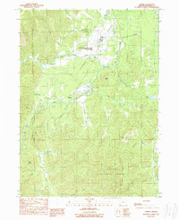
1989 Map of O'Brien
USGS Topo · Published 1989About this map
The Illinois River and its numerous tributaries dominate this 1980s landscape in Josephine County. The settlement of O'Brien sits at the junction of O'Brien Creek and the river, while the historic mining locale of Waldo is positioned further southeast near the Waldo Hill terrain. The map reveals an area defined by hydraulic and placer mining history, evidenced by features like the Esterly Mine, Logan Cut, and Gravel Cut.
Find a feature on this map
41 named features on this map. Tap any name to fly to it.
Don’t see what you’re looking for? This feature index may not catch every label — zoom into the map to look around manually.
Map Details
Editions of this 1989 O'Brien Map
This is the sole edition of this map. No revisions or reprints were ever made.
Other maps of this area

1917 · Kerby
USGS Topo · 1:125,000

1918 · Kerby
USGS Topo · 1:125,000

1922 · Preston Peak
USGS Topo · 1:125,000

1945 · Kerby
USGS Topo · 1:125,000

1945 · Gasquet
USGS Topo · 1:62,500

1948 · Weed
USGS Topo · 1:250,000

1950 · Weed
USGS Topo · 1:250,000

1951 · Gasquet
USGS Topo · 1:62,500

1954 · Cave Junction
USGS Topo · 1:62,500

1954 · Chetco Peak
USGS Topo · 1:62,500