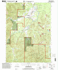
1996 Map of O'Brien
USGS Topo · Published 1999About this map
Waldo and the surrounding mining district of southern Josephine County are captured here during a period of forest management and early conservation efforts in the mid-1990s. The landscape is heavily marked by its hydraulic mining history, evidenced by the extensive Tailings and the presence of the Esterly Mine near French Flat. Local landmarks such as the Cemetery and an Historic Marker north of Waldo anchor the settlement's deep roots in the region's 19th-century gold rush legacy.
Find a feature on this map
51 named features on this map. Tap any name to fly to it.
Don’t see what you’re looking for? This feature index may not catch every label — zoom into the map to look around manually.
Map Details
Editions of this 1996 O'Brien Map
This is the sole edition of this map. No revisions or reprints were ever made.
Other maps of this area

1917 · Kerby
USGS Topo · 1:125,000

1918 · Kerby
USGS Topo · 1:125,000

1922 · Preston Peak
USGS Topo · 1:125,000

1945 · Kerby
USGS Topo · 1:125,000

1945 · Gasquet
USGS Topo · 1:62,500

1948 · Weed
USGS Topo · 1:250,000

1950 · Weed
USGS Topo · 1:250,000

1951 · Gasquet
USGS Topo · 1:62,500

1954 · Cave Junction
USGS Topo · 1:62,500

1954 · Chetco Peak
USGS Topo · 1:62,500