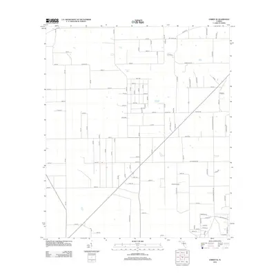
2012 Map of O'Brien SE
USGS Topo · Published 2012About this map
Cypress Lake sits in the northern reaches of this rural Columbia County landscape, surrounded by an orderly grid of country roads that define the local agricultural character. The terrain is notably level, marked by a network of thoroughfares like Central Rd and Allison Rd that connect family farms and rural homesteads. The Z Ranch Airport serves as a distinct aviation landmark in the southern half of the sheet, reflecting the utility of private airfields in these expansive Florida interiors. This 2012 survey by the U.S. Geological Survey captures the region's enduring rural structure, where family names are etched into the geography through routes such as Paul Allison Rd, Charles Rd, and Barrs Rd. The map illustrates a stable landscape of managed timber or agriculture, characterized by long, straight stretches of road like Tall Pine Rd.
Find a feature on this map
98 named features on this map. Tap any name to fly to it.
Don’t see what you’re looking for? This feature index may not catch every label — zoom into the map to look around manually.
Map Details
Editions of this 2012 O'Brien SE Map
This is the sole edition of this map. No revisions or reprints were ever made.
Other maps of this area

1954 · Gainesville
USGS Topo · 1:250,000

1954 · Valdosta
USGS Topo · 1:250,000

1958 · Valdosta
USGS Topo · 1:250,000

1958 · Gainesville
USGS Topo · 1:250,000

1959 · Valdosta
USGS Topo · 1:250,000

1959 · Gainesville
USGS Topo · 1:250,000

1963 · Columbia
USGS Topo · 1:24,000

1963 · Lake City West
USGS Topo · 1:24,000

1968 · Branford
USGS Topo · 1:24,000
1968 · Hildreth
USGS Topo · 1:24,000