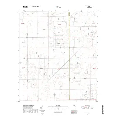
2018 Map of O'Brien SE
USGS Topo · Published 2018About this map
Cypress Lake sits as a primary natural landmark in this section of Northern Florida, where the border between Suwannee County and Columbia County divides the landscape. The terrain is defined by a dense network of rural routes and sectional lines, reflecting a region deeply rooted in agriculture and timber. Major arteries like Co Rd 240 and Watermelon Rd connect dispersed homesteads and farms. The systematic layout of the Public Land Survey System is evident here, with township and range lines like t4s r15e and t5s r15e organizing the pine-studded lowlands. Smaller local connectors such as Cross Country Rd and Dogwood Dr provide access to the interior woods and wetlands that characterize this quiet corner of the state.
Find a feature on this map
118 named features on this map. Tap any name to fly to it.
Don’t see what you’re looking for? This feature index may not catch every label — zoom into the map to look around manually.
Map Details
Editions of this 2018 O'Brien SE Map
This is the sole edition of this map. No revisions or reprints were ever made.
Other maps of this area
1954 · Gainesville
USGS Topo · 1:250,000
1954 · Valdosta
USGS Topo · 1:250,000
1958 · Valdosta
USGS Topo · 1:250,000
1958 · Gainesville
USGS Topo · 1:250,000
1959 · Valdosta
USGS Topo · 1:250,000
1959 · Gainesville
USGS Topo · 1:250,000
1963 · Columbia
USGS Topo · 1:24,000
1963 · Lake City West
USGS Topo · 1:24,000
1968 · Branford
USGS Topo · 1:24,000
1968 · Hildreth
USGS Topo · 1:24,000