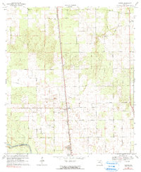
1969 Map of O'Brien
USGS Topo · Published 1990About this map
The settlement of O'Brien sits at the heart of this North Florida landscape, positioned along the Seaboard Coast Line railroad. This 1960s survey documents a rural topography defined by a high density of depression contours and sinkholes, characteristic of the local karst geology. The Suwannee River carves the southwest corner of the map, marked by Troy Spring on the Lafayette County bank. Numerous small country churches and family burial grounds, such as Pleasant Hill Ch, Mt Zion Ch, and Cedar Grove Cem, anchor the community's social geography. This era shows a transition in land use, where traditional agriculture is mapped alongside an extensive network of firebreaks and a localized Quarry, suggesting the growth of timber management and resource extraction in the Suwannee Valley.
Find a feature on this map
26 named features on this map. Tap any name to fly to it.
Don’t see what you’re looking for? This feature index may not catch every label — zoom into the map to look around manually.
Map Details
Editions of this 1969 O'Brien Map
3 editions found
Other maps of this area

1954 · Mallory Swamp NE
USGS Topo · 1:24,000

1954 · Gainesville
USGS Topo · 1:250,000

1954 · Valdosta
USGS Topo · 1:250,000

1955 · Mayo NE
USGS Topo · 1:24,000

1955 · Mayo SE
USGS Topo · 1:24,000

1958 · Valdosta
USGS Topo · 1:250,000

1958 · Gainesville
USGS Topo · 1:250,000

1959 · Valdosta
USGS Topo · 1:250,000

1959 · Gainesville
USGS Topo · 1:250,000

1968 · Branford
USGS Topo · 1:24,000