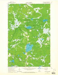
1964 Map of O'Leary Lake
USGS Topo · Published 1965About this map
The George Washington State Forest dominates this section of Itasca County, defined by a dense network of glacial lakes and river systems as they appeared in the mid-1960s. Central to the landscape is the large expanse of Buck Lake, which is fed and drained by a complex of smaller water bodies including Little Buck Lake and O'Leary Lake. The Prairie River meanders through the northern section, joined by tributaries such as Day Brook, while the East River and South Fork Lake define the southern drainage patterns. This survey is notable for its detailed bathymetric depth curves, provided by the State of Minnesota Department of Conservation, which reveal the underwater topography of these lakes. Human activity is sparse, marked primarily by the Forest Boundary and a solitary Gravel Pit, reflecting a landscape managed for conservation and natural resources rather than settlement.
Find a feature on this map
17 named features on this map. Tap any name to fly to it.
Don’t see what you’re looking for? This feature index may not catch every label — zoom into the map to look around manually.
Map Details
Editions of this 1964 O'Leary Lake Map
3 editions found
Other maps of this area

1919 · Release
USGS Topo · 1:62,500

1920 · Trout Lake
USGS Topo · 1:62,500

1943 · Release
USGS Topo · 1:62,500

1952 · Keewatin
USGS Topo · 1:24,000

1952 · Nashwauk
USGS Topo · 1:24,000

1954 · Hibbing
USGS Topo · 1:250,000

1957 · Hibbing
USGS Topo · 1:250,000

1958 · Hibbing
USGS Topo · 1:250,000

1964 · Hibbing
USGS Topo · 1:250,000

1964 · Side Lake
USGS Topo · 1:24,000