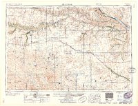
1959 Map of O'Neill
USGS Topo · Published 1959About this map
The Sand Hills of northern Nebraska dominate this mid-century landscape, where the Niobrara River and Elkhorn River carve distinct drainage patterns through the dune-like terrain. The Chicago and North Western railroad provides a central axis of connectivity, linking established cattle and rail towns like Ainsworth, Bassett, and O'Neill. To the north, the Missouri River forms the state boundary, with the Keya Paha River and Ponca Creek feeding its flow. This survey documents a rural network of small post offices and local landmarks, including the Dustin Post Office and Walnut Cem, alongside early aviation infrastructure at Perkins Memorial Airpark. The high density of windmills and small lakes throughout the hills underscores the vital relationship between groundwater and ranching in this portion of Holt County and its neighbors.
Find a feature on this map
83 named features on this map. Tap any name to fly to it.
Don’t see what you’re looking for? This feature index may not catch every label — zoom into the map to look around manually.
Map Details
Editions of this 1959 O'Neill Map
2 editions found

Other maps of this area

1898 · Olivet
USGS Topo · 1:125,000

1949 · Dutch Creek
USGS Topo · 1:24,000

1949 · Koshopah
USGS Topo · 1:62,500

1949 · Jamison SW
USGS Topo · 1:24,000

1949 · Riverview
USGS Topo · 1:24,000

1949 · Carns
USGS Topo · 1:24,000

1950 · Bassett NW
USGS Topo · 1:24,000

1950 · Norden
USGS Topo · 1:62,500

1950 · Carns
USGS Topo · 1:24,000

1950 · Riverview
USGS Topo · 1:24,000