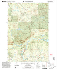
1999 Map of Oak Bluff
USGS Topo · Published 2004About this map
West Branch Ontonagon River meanders through the heart of the Ottawa National Forest, creating a landscape defined by sharp elevation changes and numerous tributary streams. The terrain is dominated by the prominent ridge of Oak Bluff, while the eastern portion of the map is shaped by the backwaters of the Victoria Reservoir. This late 20th-century revision captures a remote wilderness area where industrial markers like a Gravel Pit contrast with the primitive access routes of Location Road and Victoria Road.
Find a feature on this map
20 named features on this map. Tap any name to fly to it.
Don’t see what you’re looking for? This feature index may not catch every label — zoom into the map to look around manually.
Map Details
Editions of this 1999 Oak Bluff Map
This is the sole edition of this map. No revisions or reprints were ever made.
Other maps of this area

1949 · Matchwood NW
USGS Topo · 1:24,000

1949 · Rockland
USGS Topo · 1:62,500

1950 · Greenland
USGS Topo · 1:62,500

1951 · Rockland
USGS Topo · 1:62,500

1951 · Greenland
USGS Topo · 1:62,500

1955 · Ontonagon
USGS Topo · 1:62,500

1956 · Matchwood NW
USGS Topo · 1:24,000

1956 · Matchwood
USGS Topo · 1:62,500

1958 · Iron River
USGS Topo · 1:250,000

1960 · Iron River
USGS Topo · 1:250,000