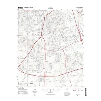
2016 Map of Oak Cliff
USGS Topo · Published 2016About this map
The southern Dallas landscape transitions from dense urban neighborhoods to the expansive green spaces of Laurel Land Memorial Park and Dallas Executive Airport. In the historic Oak Cliff district, the grid iron street pattern is punctuated by the Oak Cliff Cem, while further south, the suburban edges of DeSoto and Lancaster begin to emerge. The hydrology of the region is defined by the winding course of Fivemile Cr and its tributaries, such as Coombs Cr and Honey Springs Br, which carve through the residential blocks. Smaller communities and named locales like Lisbon, Fruitdale, and Sargent maintain their identities within the larger metropolitan area. This survey reveals the late-twentieth-century infrastructure including the intersection of major transit corridors that bypass older landmarks like the Lisbon Cem and the waters of Cedar Valley College Lake.
Find a feature on this map
73 named features on this map. Tap any name to fly to it.
Don’t see what you’re looking for? This feature index may not catch every label — zoom into the map to look around manually.
Map Details
Editions of this 2016 Oak Cliff Map
This is the sole edition of this map. No revisions or reprints were ever made.
Other maps of this area

1891 · Dallas
USGS Topo · 1:125,000

1893 · Dallas
USGS Topo · 1:125,000

1931 · Carrollton
USGS Topo · 1:62,500

1954 · Dallas
USGS Topo · 1:250,000

1957 · White Rock Lake
USGS Topo · 1:24,000

1958 · Dallas
USGS Topo · 1:250,000

1958 · Hutchins
USGS Topo · 1:24,000

1958 · Oak Cliff
USGS Topo · 1:24,000

1958 · Dallas
USGS Topo · 1:24,000

1958 · White Rock Lake
USGS Topo · 1:24,000