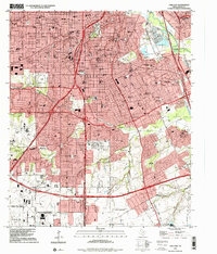
1995 Map of Oak Cliff
USGS Topo · Published 2001About this map
Oak Cliff and its surrounding residential neighborhoods define the landscape south of downtown Dallas, where the dense street grid gives way to more expansive institutional sites and recreational spaces by the mid-1990s. The northern portion of the map is heavily developed along major corridors like Davis Street and Illinois Avenue, while the southern reaches near Lancaster and Woodland Hills show a different character with larger plots and significant topographical features like Fivemile Creek. This survey details several educational landmarks including Paul Quinn College and Cedar Valley College, alongside critical regional infrastructure such as the Veterans Hospital and Redbird Airport. Transit patterns are deeply integrated, with the Missouri-Kansas-Texas RR and Gulf Colorado and Santa Fe RR skirting the urban edges while the Lyndon B Johnson Freeway provides a modern bypass through the southern sector.
Find a feature on this map
74 named features on this map. Tap any name to fly to it.
Don’t see what you’re looking for? This feature index may not catch every label — zoom into the map to look around manually.
Map Details
Editions of this 1995 Oak Cliff Map
This is the sole edition of this map. No revisions or reprints were ever made.
Other maps of this area

1891 · Dallas
USGS Topo · 1:125,000

1893 · Dallas
USGS Topo · 1:125,000

1931 · Carrollton
USGS Topo · 1:62,500

1954 · Dallas
USGS Topo · 1:250,000

1957 · White Rock Lake
USGS Topo · 1:24,000

1958 · Dallas
USGS Topo · 1:250,000

1958 · Hutchins
USGS Topo · 1:24,000

1958 · Oak Cliff
USGS Topo · 1:24,000

1958 · Dallas
USGS Topo · 1:24,000

1958 · White Rock Lake
USGS Topo · 1:24,000